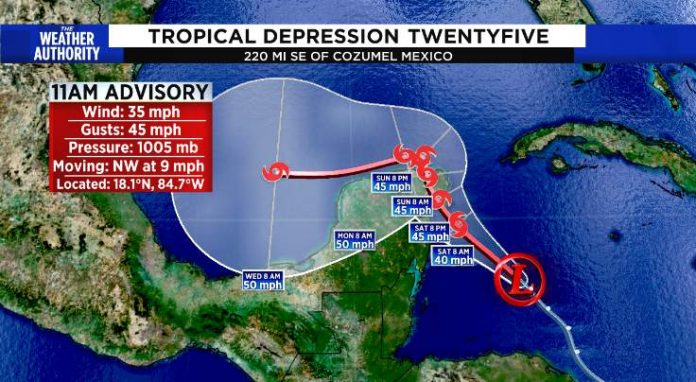
The 25th system of the 2020 hurricane season formed Friday morning. It is forecast to move into the Gulf as it intensifies into Tropical Storm Gamma.
How much it can further organize and strengthen around a well-defined center before it interacts with the Yucatán Peninsula — Mexico and Belize — is still an open question, but it appears there is time for it to become a tropical storm. The system is forecast to be near the coastline tomorrow.
There is also a slight chance the center will track far enough north that it can shoot between Mexico and Cuba through the Yucatán Channel and stay over water. In that case, it could gain more strength since much of the circulation would be over water. Current trends indicate that’s a small chance, however, since the most pronounced circulation is currently fairly far south, off the coast of Belize.
If it continues to organize, and it strengthens so that sustained winds are at least 40 mph, it will be called Tropical Storm Gamma.
The consensus of the computer forecast models is that the disturbance, or whatever it becomes, will be eventually steered into the southwestern Gulf of Mexico by a broad area of low pressure over Central America. It’s a common feature this time of year called a Central American Gyre – a gyre being a system with a broad rotation. This big system generates heavy rains over land, even without the embedded disturbance.
The upper-level winds are conducive for Tropical Depression #25 to organize and strengthen. The deterrent appears to be its likely track over land. When it reaches the southwestern Gulf of Mexico in a couple of days, however, the atmospheric environment is forecast to become somewhat more hostile. So, significant further strengthening is not expected during the first part of next week even though it will be back over the water.
A dip in the jet stream will reach into the Gulf of Mexico over the next couple of days. It does not appear that the dip will extend far enough south to lift the disturbance north, but it will grab moisture from the large area of disturbed weather over Central America and drag it over South Florida.
The National Weather Service in Miami has issued a Flood Watch due to periods of heavy rain that are expected to move across South Florida through a good part of the weekend. That dip in the jet stream is forecast to lift back north by Monday.


